Address
304 North Cardinal St.
Dorchester Center, MA 02124
Work Hours
Monday to Friday: 7AM - 7PM
Weekend: 10AM - 5PM

Address
304 North Cardinal St.
Dorchester Center, MA 02124
Work Hours
Monday to Friday: 7AM - 7PM
Weekend: 10AM - 5PM

Explore the technologies powering space exploration, from satellites, remote sensing and navigation to robotics, artificial intelligence, advanced materials, spacecraft communications, power systems and in-space manufacturing.
A spacecraft may look like a single machine, but it is really a meeting point for thousands of technologies: sensitive detectors, autonomous computers, advanced materials, power systems, precision navigation, robotics and communication networks. Some are built specifically for space. Others are adapted from discoveries made on Earth and pushed into conditions where failure is not an option.
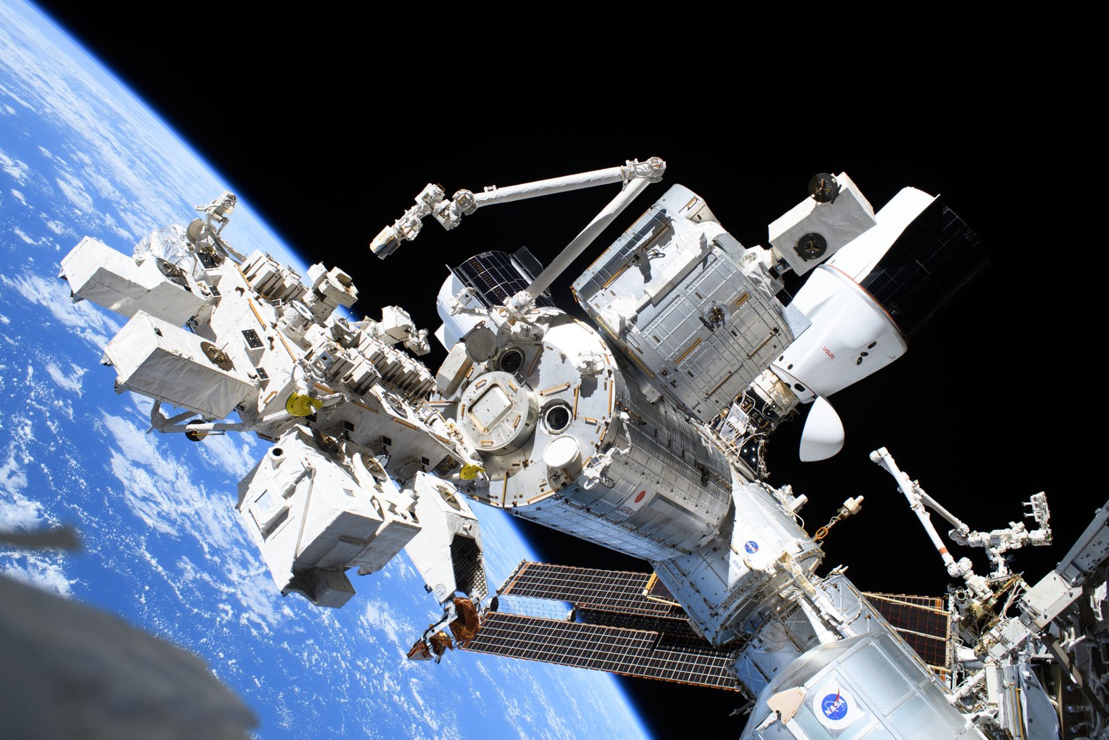
Space technology is much bigger than rockets. It includes the systems that help us observe Earth, predict weather, navigate across continents, communicate over long distances, explore other worlds and understand the universe. It also includes the tools that allow spacecraft to survive radiation, vacuum, extreme temperatures and years without hands-on repair.
Space technology includes the hardware, software, materials, infrastructure and operating methods used to access space, work there and make use of information gathered from it. Some systems fly in orbit; others remain on Earth as launch facilities, tracking stations, data centres and mission-control networks.
It is useful to think of space technology as a connected system rather than a collection of gadgets. A satellite needs sensors to collect information, power to operate, computers to process commands, communications to send data home and ground systems to turn that data into something useful.
Satellites are among the most visible and widely used products of space technology. They serve different purposes depending on their orbit, instruments, communications equipment and mission design.
Relay television, telephone, broadband and data traffic. Coverage and signal delay depend on orbit, network design, frequency bands and ground infrastructure.
Transmit precise timing and orbit information that receivers use to estimate position and time. Systems include GPS, Galileo, GLONASS, BeiDou and India’s NavIC.
Measure land, oceans, atmosphere, vegetation, ice, fires, cities and environmental change using optical, infrared, radar and other sensors.
Track clouds, storms, atmospheric temperature, moisture and long-term environmental indicators. Different orbits provide different viewing frequency and geographic coverage.
Observe the Sun, Earth’s magnetosphere, cosmic radiation, distant galaxies and phenomena difficult to study from the ground.
Test new instruments, propulsion, communication methods, materials, formation flying or small-satellite platforms before wider use.
Satellites do not all occupy the same orbit. Low Earth orbit offers relatively short signal paths and frequent passes; geostationary orbit allows a satellite to remain over roughly the same longitude; medium Earth orbit is used by many navigation constellations; and highly elliptical orbits serve specialised coverage needs.
Remote sensing means collecting information about a target without physically touching it. Satellites can measure reflected sunlight, emitted heat, microwave signals, radar backscatter and other forms of electromagnetic radiation. Each measurement reveals different properties of the surface or atmosphere.
Records reflected visible and near-infrared light. It can map crops, forests, coastlines, cities and surface changes, but clouds and darkness can limit observations.
Measures emitted thermal radiation and can help map surface temperature, heat patterns, fires and some atmospheric properties.
Uses microwave signals to image the surface, including through many cloud conditions and at night. Radar data can reveal flooding, land deformation, ice movement and surface structure.
Separate light into wavelengths to identify materials, gases, minerals and atmospheric composition.
Remote sensing data is not automatically a direct photograph of reality. Sensors have resolution limits, viewing geometry, calibration needs and uncertainty. Scientists use processing, ground measurements and models to interpret what an instrument actually recorded.
Spacecraft communicate using radio waves and, in some demonstrations and systems, optical or laser links. Antennas transmit commands and scientific data between spacecraft and ground stations. The design must account for distance, signal strength, interference, power, pointing accuracy and data volume.
As distance increases, communication becomes harder. Signals to the Moon take roughly a second and a quarter one way; signals to Mars can take several minutes to more than twenty minutes one way, depending on planetary positions. A distant spacecraft cannot be flown like a remotely controlled drone. It needs onboard autonomy to manage routine operations and respond safely before Earth can reply.
Deep Space Network facilities use large antennas at widely separated locations to maintain contact as Earth rotates. Ground networks are as important to deep-space exploration as the spacecraft itself.
Spacecraft must know where they are, where they are going and how they are oriented. Navigation can combine radio tracking from Earth, star trackers, gyroscopes, accelerometers, optical cameras, radar and other sensors. No single method works for every mission.
Guidance determines the intended path or manoeuvre; navigation estimates the spacecraft’s state; control commands thrusters, reaction wheels or other actuators to carry it out. Together, these functions are often called guidance, navigation and control (GNC).
Compare observed star patterns with catalogues to determine spacecraft orientation.
Gyroscopes and accelerometers measure changes in rotation and motion, helping estimate movement between external observations.
Cameras observe planets, moons, asteroids or stars to refine position and trajectory, particularly during approach and landing.
Onboard software can analyse images and sensor data to select safer paths or trigger protective responses when communication delays make ground control impractical.
Robotic systems extend exploration into places that are dangerous, distant or too expensive for people to visit. Robotic arms can capture cargo spacecraft and move station components. Rovers traverse planetary surfaces. Landers, drills and sample systems investigate terrain and collect material for analysis.
Space robotics must handle communication delays, dust, temperature extremes, uncertain terrain, limited power and strict mass constraints. A robot operating on Mars cannot depend on a human operator steering every wheel movement in real time. It needs to interpret its surroundings and make carefully bounded decisions on its own.
Spacecraft increasingly generate more data than can be transmitted continuously to Earth. Onboard computing can prioritise observations, detect events, compress data, monitor equipment and help schedule operations. Machine-learning methods may identify patterns in images or sensor streams, but they must be validated for the mission and consequences of error.
Space computing has unusual constraints. Radiation can cause memory errors or damage electronic components; power and cooling are limited; hardware may be difficult to replace; and software updates must be carefully controlled. Some systems use radiation-hardened processors, error-correcting memory, redundant computers and fault-tolerant software.
AI is not a magic replacement for mission control or scientific judgement. A model can be wrong, biased by its training data or uncertain outside its intended operating conditions. Safety-critical decisions require validation, monitoring, fallback modes and clear responsibility.
Space hardware must withstand launch vibration, vacuum, radiation, temperature cycling, atomic oxygen in some orbits and long exposure to the environment. Engineers select materials for strength, mass, thermal behaviour, radiation tolerance, outgassing and resistance to degradation.
Advanced alloys, composites and carefully designed structures reduce mass while maintaining stiffness and strength under launch loads.
Insulation, coatings, heat pipes and radiators help control temperatures. Multilayer insulation reduces unwanted heat transfer in vacuum.
Component selection, shielding, circuit design and fault recovery help systems operate in radiation environments.
Three-dimensional printing can create complex shapes and may support production of tools or replacement parts in space. Routine, large-scale orbital manufacturing is still developing.
Spacecraft need electricity for computers, communications, heaters, instruments, motors and life-support systems. Solar arrays are common for missions near the Sun, but available sunlight decreases with distance and can be interrupted by eclipses or surface shadows.
Batteries store energy for periods without sunlight or for high-power operations. Radioisotope power systems convert heat from radioactive decay into electricity or useful thermal energy and are valuable for some missions far from the Sun. They are not nuclear reactors; their operating principle and power output are different.
Future surface missions may need combinations of solar power, energy storage, fuel cells or nuclear fission power systems. The right choice depends on location, duration, dust, temperature, maintenance and energy demand.
Most spacecraft have historically been designed to operate without repair. That is beginning to change. Robotic servicing can inspect, refuel, reposition or potentially repair satellites. In-space assembly could allow large structures to be built from multiple launches. Manufacturing in microgravity may produce materials or structures with properties difficult to achieve on Earth, although commercial value and production quality must be demonstrated.
These capabilities could extend satellite lifetimes, reduce replacement launches and support future telescopes, stations and exploration vehicles. They also raise questions about ownership, safety, liability, compatibility and the risk of creating debris during servicing operations.
Space technology is a global field. Countries build different strengths around scientific goals, industrial ecosystems, budgets and strategic priorities. The examples below are illustrative rather than exhaustive or ranked.
The United States combines NASA science and exploration programmes, military and civil satellite systems, universities, research laboratories and commercial aerospace companies. Areas of strength include deep-space science, Earth observation, navigation, communications, space telescopes, robotics, launch services and commercial satellite networks.
NASA missions have advanced planetary robotics, autonomous navigation, scientific instruments, life-support systems and space communications. Commercial companies contribute launch, satellite, crew transportation and in-space services. The wider ecosystem includes many private suppliers and academic research groups rather than one single programme.
Reference: NASA — official programmes and research.
India’s space technology ecosystem includes launch vehicles, Earth-observation satellites, communications, meteorology, navigation and planetary science. ISRO’s remote-sensing missions support agriculture, water resources, land-use mapping, disaster management and ocean observation. INSAT and GSAT systems support communications and meteorological services, while NavIC provides regional navigation capability.
India’s scientific missions, including Chandrayaan, Mars Orbiter Mission, Aditya-L1 and AstroSat, have developed and used instruments for lunar, planetary, solar and astronomical research. The ecosystem also includes emerging private companies working on launch vehicles, satellite platforms, propulsion, ground systems and data applications. The private sector is growing while ISRO remains a central technical institution.
References: ISRO — official missions and programmes · ISRO — applications.
Russia’s space technology base developed through the Soviet space programme and includes launch vehicles, rocket engines, crewed spacecraft, orbital modules, navigation satellites and scientific missions. Its long experience in human spaceflight has contributed to life-support engineering, docking systems, spacewalk operations and long-duration station maintenance.
Russian capabilities also include GLONASS navigation, Earth-observation and communications satellites, and scientific instruments. The present state of individual projects and partnerships can change, so historical achievements should be distinguished from current operational capacity and future proposals.
Reference: Roscosmos.
China has developed capabilities across launch vehicles, communications, navigation, Earth observation, crewed spaceflight, space stations and robotic lunar and planetary exploration. The BeiDou navigation system provides global services, while the Tiangong station supports crewed research and technology development. Chang’e and Tianwen missions have advanced China’s lunar and planetary science capabilities.
China’s space technology system includes state institutions, research organisations and a growing commercial sector. Public information about some capabilities and schedules may be limited or change over time. Claims should be grounded in specific mission evidence and official programme information.
References: CNSA · China Manned Space Agency.
Space technology produces direct services and also creates knowledge, tools and engineering methods that can be useful in other fields. Some benefits come from satellites themselves; others arise from research, specialised manufacturing or the need to solve difficult engineering problems.
Satellite observations support storm tracking, flood mapping, wildfire monitoring, drought assessment and emergency planning.
Satellite navigation supports transport, logistics, surveying, precision agriculture and timing systems used by communications and infrastructure networks.
Long-term observations help researchers monitor sea level, ice, forests, atmospheric composition, ocean conditions and land change.
Research for space can contribute to advances in sensors, robotics, thermal systems, lightweight structures, imaging and remote operations. Benefits vary by technology and should be demonstrated rather than assumed.
It is important not to repeat exaggerated claims that every modern product is a direct result of the space programme. Many technologies have multiple origins. A credible account identifies the actual connection and avoids treating coincidence as proof of technology transfer.
More capability creates new responsibilities. Satellite constellations can improve connectivity but also increase congestion and collision risk. High-resolution Earth observation can support environmental protection while raising privacy and security questions. Space debris can threaten operational spacecraft and future access to orbit.
Responsible innovation includes end-of-life disposal, collision avoidance, transparent coordination, cybersecurity, radio-frequency management, planetary protection and careful treatment of sensitive data. A technology is not successful simply because it works; its broader consequences matter.
Several fields could become increasingly important: more capable small satellites, optical communications, autonomous spacecraft operations, robotic servicing, in-space manufacturing, advanced power systems, improved radiation-tolerant computing and instruments that can analyse samples or detect transient events with less dependence on Earth.
Some of these capabilities already have operational examples. Others are being demonstrated in limited settings or remain research goals. The most consequential innovations may be the ones that make space systems more reliable, affordable, maintainable and useful—not necessarily the most visually spectacular.
Space technology includes the hardware, software, materials, infrastructure and methods used to access space, operate spacecraft, collect data and support applications such as communications, navigation, Earth observation and scientific research.
A satellite is an object that orbits another body. Many artificial satellites are spacecraft, but the term spacecraft also includes vehicles that travel between worlds, landers, probes and crewed vehicles that may not remain in orbit.
Ordinary optical cameras generally cannot see through thick clouds. Radar instruments use microwave signals and can observe many surfaces through cloud cover and at night, although radar images require specialised interpretation.
They typically use radio links and antennas to transmit data and receive commands. Some missions also demonstrate optical communications. Deep-space missions use large ground antennas and must account for long signal delays.
AI and machine-learning methods can help classify images, identify events, prioritise data and support autonomous operations. Safety-critical uses require validation, monitoring and fallback systems because models can make mistakes.
Remote sensing is the collection of information about an object or area without direct physical contact. Satellites use optical, infrared, radar and other instruments to study Earth’s surface, oceans and atmosphere, as well as other planets.
NavIC is India’s regional satellite navigation system, designed to provide positioning, navigation and timing services over India and an area around it. It complements other global navigation satellite systems.
Yes. Satellite services support weather forecasts, disaster response, navigation, communications, mapping, agriculture, environmental monitoring and many other activities used in daily life and public services.
Some satellites and spacecraft have been serviced or repaired in orbit, and robotic servicing technology is developing. It is not yet practical or economical to repair every satellite, because designs, interfaces and mission conditions differ.
Space technology connects the vehicles we build, the journeys we plan and the future of a civilisation working beyond Earth.
These institutional resources provide further context: